More fragmentized urban form more CO$_2$ emissions? A comprehensive relationship from the combination analysis across different scales
Abstract
Scientifically delineating the spatial heterogeneity of urban landscape fragmentation in relation to CO$_2$ emissions helps the urban carbon mitigation strategy. The combination analysis across spatial resolutions, which is rare, helps explore the comprehensive relationship between urban fragmentation and CO$_2$ emissions. This study compared the relationships between urban form fragmentation and CO$_2$ emissions in an urban system through the analytic framework composed of the Pearson correlation analysis, geographically weighted regression (GWR), and geographical detector methods with the use of multi-source data to construct the CO$_2$ emissions maps. As the result, there was less fragmentation with a 500-m spatial resolution (R500m) than with a 30-m spatial resolution (R30m). In terms of the GWR analysis, the coarse resolution resulted in, 1) positive coefficients of fragmentation metric becoming negative, and 2) greater absolute values of negative coefficients. As to the results of Geographical detector, single factor impact powers and interactions among fragmentation factors showed a weakening effect at R30m, but a strengthening and weakening effect at R500m. However, there were common results observed in low-fragmented areas across different scales. That is, in low-fragmented mixed-function areas and industrial areas, the more fragmented the area was, the less the CO$_2$ emission there would be. However, in low-fragmented residential, administrative and public service areas, the more fragmented the area was, the higher the CO$_2$ emission there would be. Therefore, the government should disperse the mixed function zones and industrial parcels with diverse types of land, and build the contiguous residential and public service land in the low fragmentation area of urban system. The results of this study can provide a reference for the other small and medium towns and cities. The analytical framework can be applied to CO$_2$ emissions research in urban agglomerations, megacities, and small towns.
Highlights
- Use of multi-source data and an analytical framework composed of 3 methods.
- Exploration of the impact of 30-m versus 500-m spatial resolution.
- Low fragmented mixed and industrial lands affect CO$_2$ emissions negatively.
- Low fragmented residential and public lands affect CO$_2$ emissions positively.
- Interactions of factors are weaker at a 30-m resolution than at a 500-m resolution.
Overview
Besides the industrial production, transportation, local weather, and fossil fuel use, urban form is the factor that affects energy-related CO$_2$ emissions from human activities secondarily. The major forms of human activity affected by urban form are traffic and residential energy consumption/use emissions. After a wide examination of the relationship between urban higher fragmentation and CO$_2$ emissions, scholars found fragmentation of land use areas (i.e. areas designated for human activities or purposes) is associated with greater CO$_2$ emissions. However, the evidences might be biased by the uncertainties from the spatial distribution of emissions (also referred to “downscaling”, or “representation” uncertainty), the delineation of urban fragmentation landscape, and the analysis method, which ignores the spatial heterogeneity. Zuo et al. (2019) published the study in the Journal of Cleaner Production, which compared the relationships between urban form fragmentation and CO$_2$ emissions in an urban system through the analytic framework composed of the Pearson correlation analysis, geographically weighted regression (GWR), and geographical detector methods with the use of multi-source data to construct the CO$_2$ emissions maps. The analytical framework can be applied to CO$_2$ emissions research in urban agglomerations, megacities, and small towns.
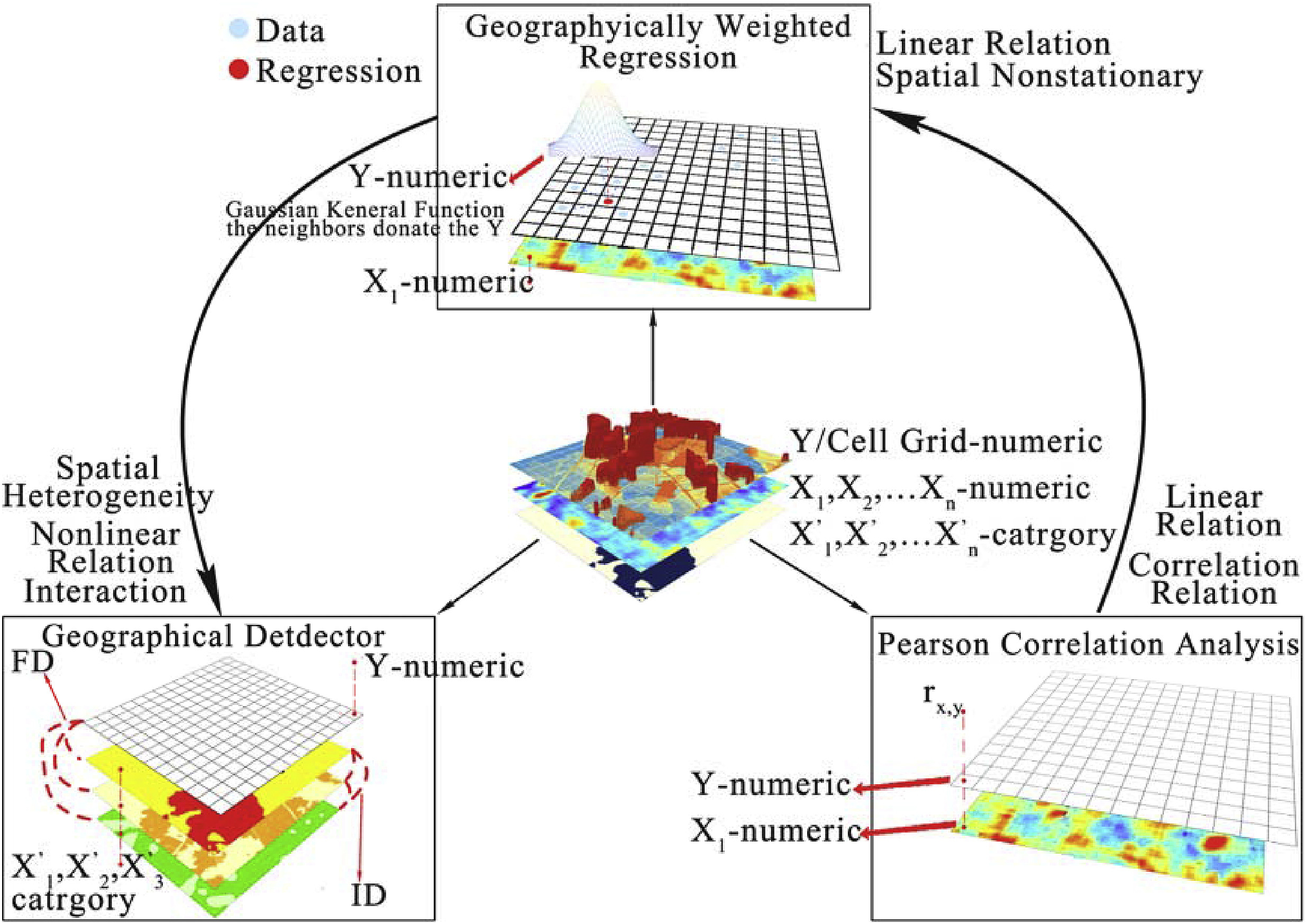
Figure 1 Analytical Framework
Results
In terms of the GWR analysis, the coarse resolution resulted in: 1) positive coefficients of fragmentation metric becoming negative, and 2) greater absolute values of negative coefficients. As to the results of Geographical detector, single factor impact powers and interactions among fragmentation factors showed a weakening effect at R$_{30m}$, but a strengthening and weakening effect at R500m. However, there were common results observed in low-fragmented areas across different scales. That is, in low-fragmented mixed-function areas and industrial areas, the more fragmented the area was, the less the CO2 emission there would be. However, in low-fragmented residential, administrative and public service areas, the more fragmented the area was, the higher the CO$_2$ emission there would be. Therefore, the government should disperse the mixed function zones and industrial parcels with diverse types of land, and build the contiguous residential and public service land in the low fragmentation area of urban system.

Figure 2 Geographical detector results for fragmentation factors, PUA, and POID for CO$_2$ emissions from 4 sources.
The “Scale effect” has always been the hot topic in landscape ecology research. Although, there are many studies on the driving force of urban environmental problems by using landscape metrics. Most studies are carried out in regional, continental and global scales. However, in this study, we explored the relationship between the urban form fragmentation and CO$_2$ emissions in the city scale from the perspective of dual resolution sizes and summarized the research conclusions that can be used in urban internal management based on the analysis results of small towns. At the same time, the influence of scale effect and how to choose the appropriate scale were discussed in the discussion section. The rigorous discussion was also made on whether the research conclusion is applicable to medium and large cities.