The importance of the functional mixed entropy for the explanation of residential and transport CO$_2$ emissions in the urban center of China
Abstract
The influence of urban spatial form on the environment is complex and lengthy. The spatial analysis for the urban form and residential-related CO$_2$ emissions at the city scale is challenging due to the lack of extensive urban form data and fine-grain CO$_2$ emission maps. This research uses remote sensing data and downscaling interpolation to generate residential and transport (RTCE) maps in 130 m spatial resolution of urban center regions from 31 major cities in China, then investigates the relationship between 3 types of urban form indicators (Internal characteristics, external morphology, and development intensity) and RTCE through Geographical Weighted Regression method. The results reveal that urban form indicators could explain about 45.9% of RTCE. The 2D building shape indicator has the second greatest positive impact as the external morphology indicator, which complicates the influence. The internal characteristics indicators have relatively strong influences than the development intensity indicators. For instance, the influence of functional mixed entropy (FME) is the greatest positive influence and decreases exponentially with FME increases. Therefore, cities with the FME lower than the threshold (0.28) should increase it appropriately, while cities with the FME around and larger than 0.28 should maintain and probably reduce it.
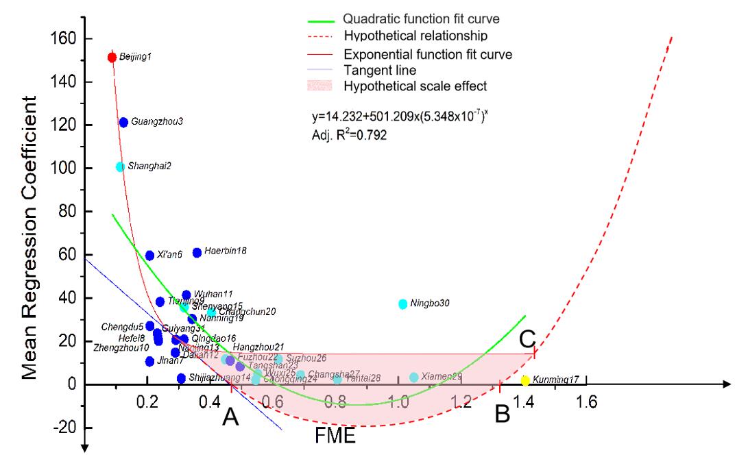
Figure 1 The relation between the functional mixed entropy and the GWR mean regression coefficients in 31 cities. The red, yellow, light blue and blue dot represents the Type Ⅰ, Ⅱ, Ⅲ and Ⅳ city, respectively. The numbers follow the city names represent the size order of the urban area. Point A, B and C are hypothetical.